
A vast scar is opening under our feet, stretching across a continent and reshaping maps yet to exist. Geologists trace a chain of fractures where land thins, buckles, and slowly parts, while volcanoes, earthquakes, and deep valleys reveal what works below the crust. In that widening path, a new ocean will one day rise, carried by water and time, carving fresh coasts, redirecting trade, and rewriting futures. The evidence stands on the ground and in space, and the story builds with every tremor.
Where the African Plate Is Splitting and Why It Matters
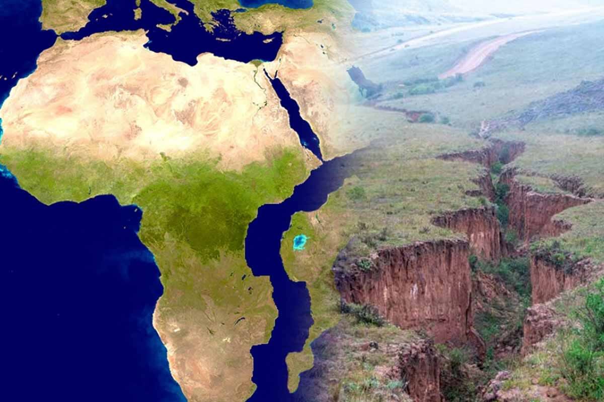
Across East Africa, a connected rift system stretches more than 6,000 kilometers from the Afar triangle to Mozambique. The crust there thins and fractures along long valleys and fault scarps. Magma rises, heat softens rock, and the surface gives way as the continent begins a measured, irreversible parting.
Ethiopia, Somalia, Kenya, and parts of Tanzania sit at a triple junction where the Somali, Nubian, and Arabian plates pull apart. Their slow divergence loads the crust with stress. As strain releases, the ground shakes, vents open, and deep grabens drop, mapping the architecture of a continent in motion.
Volcanoes rim these valleys, earthquakes rattle towns, and lakes occupy fresh basins as faults step down. Scientists read these clues like survey lines, because each feature marks how lithosphere stretches and thins. The pattern points toward seawater someday occupying this corridor, the earliest signature of a <strong.
How a Continental Rift Opens Toward a new ocean
As plates separate, the rift widens and drops, then water eventually invades the lowest ground. Seawater from the Red Sea and the Indian Ocean will flood future basins, once the barrier ridges subside and fracture. That is how ocean basins begin: by stretching continental crust until it yields.
The Horn of Africa, at the gateway to the Red Sea and the Suez Canal, stands in a pivotal position for global trade. As separation grows, that promontory will detach and become an island off mainland Africa. New shorelines will frame shipping routes, fisheries, and security priorities for decades to come.
Geologist Gilles Chazot of the University of Western Brittany describes this sequence as the textbook path to ocean birth. Continental masses fracture, valleys elongate, volcanic centers align, and water eventually enters to create a stable marine environment. The same choreography shaped ancient seas that define maps today.
Living With a Moving Ground: Risks, Benefits, and Good Practice
Rift zones reshape daily life. Towns face earthquake risk, lava hazards, and ground fissures that cut roads and pipelines. Engineers design flexible infrastructure, reroute corridors, and monitor slopes that might fail after rain. Farmers adapt to new lakes and soils, while planners weigh risk maps when approving new housing.
Scientists gain a working laboratory. Instruments track strain, gas, and tremors, building models that predict which faults link and when magma stalls or moves. That knowledge improves early warnings. It also helps governments update codes, insure critical assets, and plan for water resources in growing rift lakes.
Wildlife responds as wetlands, escarpments, and alkaline lakes expand. New habitat forms along fresh shores, while corridors fragment elsewhere. Researchers study these changes to guide conservation that balances people and biodiversity. The long arc trends toward a marine passage, the seed of a future new ocean, even as communities adapt today.
Timeframes, Telltale Fissures, and What the Numbers Mean
Continental drift usually advances by millimeters each year, sometimes a few centimeters in faster zones. Yet rifting also jumps in bursts. In 2005, western Ethiopia cracked open along a 60-kilometer fissure within minutes, with ground blocks separating by about two meters. A movement that normally spans centuries unfolded.
Such pulses do not finish the job. They highlight where strain collects and how magma lubricates faults. Teams mapped the rupture, compared satellite tracks, and measured gases to refine timelines. The long trend still runs slow, yet every step moves the region toward seawater and the outlines of a nascent new ocean.
Geodesy records steady divergence across the Somali and Nubian plates, with the Arabian plate also in play. Rates vary by site, and local geology governs how faults link. The pattern matches models that forecast sagging basins, aligned volcanoes, and widening valleys, milestones on the road from continent to ocean basin.
Why the World Should Prepare for a new ocean Across Africa
Trade routes will adjust as coasts emerge. Ports could shift location, canals may require defenses, and submarine cables will cross different floors. Energy planners, insurers, and shipowners already weigh geological risk because infrastructure lasts decades. Acting early saves cost, protects people, preserves options for growth, and avoids stranded assets.
Landscapes along the separation zone already inspire awe. The Great Rift Valley hosts tiered escarpments, chain volcanoes, and long lakes that fill deep basins. Mount Kilimanjaro rises nearby, a sentinel above the rift shoulders. Tourism grows around these features, yet safety planning remains essential where faults creep and vents awaken.
Policy choices shape who benefits. New fisheries can thrive, but rules must support coastal communities and biodiversity through science-based quotas and protected areas. Research funding lifts local universities and monitoring networks that serve the region. Regional cooperation strengthens evacuation plans and building standards so growth proceeds with eyes wide open.
What This Slow Fracture Tells Us About Earth’s Future
Continents feel permanent until they move. Here, the crust stretches, valleys deepen, and lakes lengthen, signaling a planet that never sleeps. Satellite tracks and field notes align on the same message: separation proceeds, step by step. In time, water will claim the lowest ground and sculpt an enduring marine passage. The coming new ocean will write coastlines, redirect commerce, and remind us that Earth evolves under steady hands, with patience measured in lifetimes.